Full article about Gafanha da Nazaré: born from shifting sand and salt wind
Follow iodine air to a fishing town that rose from dunes beside Portugal’s tallest lighthouse
Hide article Read full article
Sand that Became a City
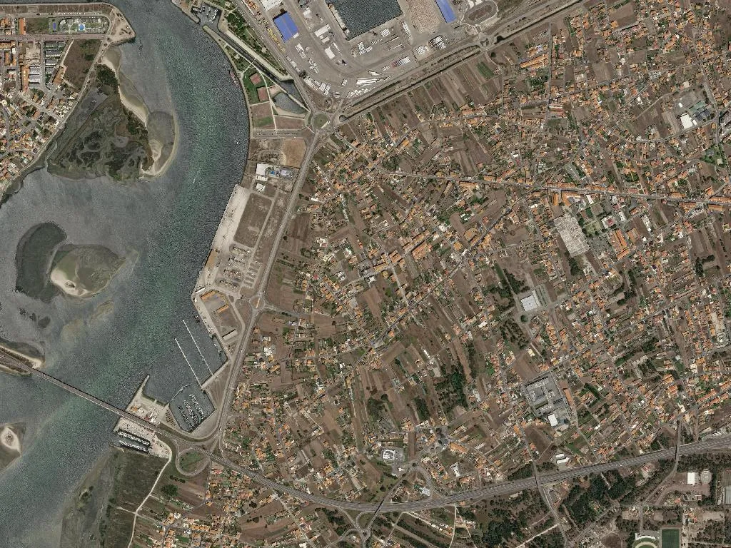
Salt arrives before the ocean. Minutes before you actually see water, the Atlantic’s breath is already on your skin – iodine, brine, the faint metallic tang that dries your lips. Then comes the hush-roll of surf, a bass note audible four hundred metres away, braided with gull cries looping over the Mira Channel. Gafanha da Nazaré sits only four metres above sea-level; that near-horizontal relationship with the sea defines everything – the weight of the light, the taste of the air, the cadence of the day.
Streets that Used to be Dunes
Nothing you see was meant to be here. In the mid-1600s the site was simply shifting sand, a mobile dune field blown inland by Atlantic gales. Sebastião Carvalho da Costa’s 1758 almanac lists fourteen hearths – fourteen stubborn households pegged to freshly embanked ground. Fisher-farmers drifted down from the interior parishes of Vagos and Mira throughout the 19th century, draining, planting, replacing timber shacks with lime-washed brick. The name “Gafanha” surfaces in a 1677 toll-bridge receipt; another story links it to a short-lived leper hospital (gafos = lepers). The settlement belonged to Vagos until 1835, gained parish autonomy on 31 August 1910 – the last created under the Portuguese monarchy – and never stopped accreting: village in 1969, town in 2001. Today 15,551 people live on the same sliver that, three centuries ago, was wind and silica.
Sixty-Six Metres of Light Above the Bar
Portugal’s tallest lighthouse rises 66 m above mean sea-level, its chalk-striped tower visible 50 km out. Inaugurated 15 October 1893 and budgeted at a parsimonious 25 contos de réis, the stonework still throws a 360° shadow across Praia da Barra. Climb 288 spiral steps and the view unwraps: the Ria de Aveiro’s brown-green tentacles to the north, the Atlantic’s blank horizon west, the saw-toothed coast south as far as the haze allows. Beside it, the squat 1640 Forte da Barra once guarded the harbour mouth; now it’s a weather-beaten relic where teenagers picnic on wind-proof walls.
Cod Painted on Walls
Avenida dos Bacalhoeiros is an open-air storyboard. António Conceição’s 2015 murals “Faina Maior” sprawl across entire façades: oil-skinned men coiling line in Newfoundland sleet, women racking salt cod under high-summer glare. The palette – cobalt, ochre, engine-oil black – is too saturated to be mere decoration; it is memory baked into plaster. Captain Henrique Silva, born here in 1922 and later master of the four-masted schooner Santa Maria Manuela, appears mid-mural, sextant in hand. At the avenue’s inland end, the parish church of Nossa Senhora da Penha de França (1904-44, neo-Renaissance by Francisco de Oliveira Ferreira) anchors the town. Each September, around the 8th, the square in front becomes a dance floor for the patron-saint festival: brass bands, grilled-eel stalls, a fireworks barrage reflected in the ria.
Eels, Salt and the Sweetness of Ovos Moles
Market days – Tuesday and Friday – begin with charcoal smoke and the hiss of eel fat dripping onto embers. Espetadas de enguia arrive straight from the Ria de Aveiro, skin blistered, flesh custard-white. The accompanying corn bread is strictly functional, a sponge for the rust-red stew of paprika and coriander. Winter brings lagareiro cod baked in garlic-olive oil, summer brings beach-grilled sardines and custard-filled bolas de Berlim. Yet the postcard sweet is Aveiro’s ovos moles – PGI-protected thin wafers shaped like clams or sardines, pumped with yolk-sugar cream: the ocean reimagined as dessert.
Between the Lagoon and the Breakers
Praia da Barra has flown the Blue Flag since 1987 and was one of Portugal’s first “Beach for All” wheelchair-accessible stretches. A straight two-kilometre band of sand faces clean, consistent swell – surf schools at the southern end, bodyboarders closer to the jetty. Turn your back to the Atlantic and you’re looking at the Ria de Aveiro, calm as a lake. The Jardim Oudinot river-beach offers lifeguarded lagoon water, open-air cinema in July, and concerts where the only backdrop is pine shadow. A five-kilometre sea-level cycleway – part of the Caminho da Costa pilgrimage route – stitches Gafanha to the candy-striped houses of Costa Nova. Traditional moliceiro boats – high-prowed, carnival-painted – still ferry visitors past salt-pans where seawater evaporates to glassy flakes. Inland, the Mata da Gafanha pine belt was planted 1938-42 to stop dunes swallowing the new roads; today its needles crunch like cornflakes under trainers.
A Beam that Swings
Dusk is the moment. The lamp ignites, the first white blade sweeps across the dark bar mouth, vanishes, returns, vanishes again. Seen from Jardim Oudinot, wood-smoke from a sardine grill still hanging in the air, the pulse is the only moving thing on the horizon. A town that began as a sandbank breathes to that rhythm: steady, stubborn, visible 50 km out – proof that the wind did not, after all, carry it away.