Full article about Ereira: where rice fields breathe with the tide
Sluice gates, stone chapels and eel-scented kitchens shape life in Coimbra’s flood-basin village
Hide article Read full article
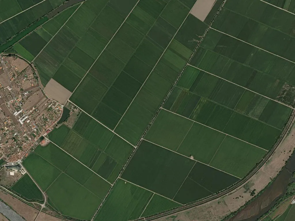
The plain runs ruler-straight until it dissolves into haze: emerald when the Carolino rice is up, ochre after the blades are cut, umber when the paddies rest. At 1.4 m above sea level Ereira is a place that measures time with water – sluice gates click open at the tide’s cue, canals glint like set-square scratches across the Baixo Mondego flood-basin. A heron’s bark or the faraway cough of a John Deere are the only sounds that disturb the dense, dew-loaded air at dawn.
Water Logic
This is not a romantic riverside. The 575 residents treat hydraulics as blood chemistry: one miscalculation and brackish water invades the root zone. Their calendar is a spreadsheet of lunar tides, winter rainfall and the 160-day vegetative cycle of the short-grain Carolino rice that holds the IGP seal. Ditches are cleaned on Saint Simon’s day, gates re-sealed before All Saints, pump houses tested when the first egret returns. Failure is measured in salinity parts per million, not folklore.
Stone & Creed
Eight classified monuments for 724 hectares is a ratio English counties reserve for cathedral closes. Three are National Monuments, four are Listed Buildings of Public Interest – yet nothing rises above the poplar line. Faith here is lateral: limestone blocks hauled from Ançã quarries 30 km away, laid in walls thick enough to withstand the Mondego’s tantrums. The 14th-century capitals in the parish church of São Pedro retain the original toolmarks; a side-chapel altarpiece records the 1629 flood level like a holy watermark. Wayside crucifixes, tiled bibelots to local saints, mark field boundaries more precisely than any GPS.
Kitchen Cartography
Tourist menus don’t exist. Rice is cooked with eel trapped in the feeder channels or with ducks that fatten on spilled grain; both recipes require the same 1.8:1 water-to-grain ratio, the same final-minute flourish of cured presunto fat. Carne Marinhoa DOP – meat from the auburn cattle you see grazing the bunds – is braised until the collagen turns the sauce into lacquer. The parish’s only café charges 80 cents for an imperial; if Zé is behind the counter he may produce a cloth-wrapped cheese his wife pressed the night before, still imprinted with the weave of the tea-towel.
Horizontal Living
Two self-catering houses, both converted haylofts, confirm Ereira is absent from every algorithmic itinerary. Population density is 79 per km² – half that of the Yorkshire Dales – so silence is guaranteed. Park outside your door; walk without a map because orientation is elementary: keep the poplars on your left and you’ll hit the river, follow the irrigation ditch and you’ll loop back to the church. Dusk transforms the watercourses into copper wires and stretches poplar shadows into infinite ladders. No summits interrupt the sightline; only the slow hiss of water through an open gate keeps score of passing time.