Full article about Friúmes & Paradela: Where Two Rivers Write a Parish
Granite villages, candle-lit chapels and river breath between the Alva and Mondego in Penacova.
Hide article Read full article
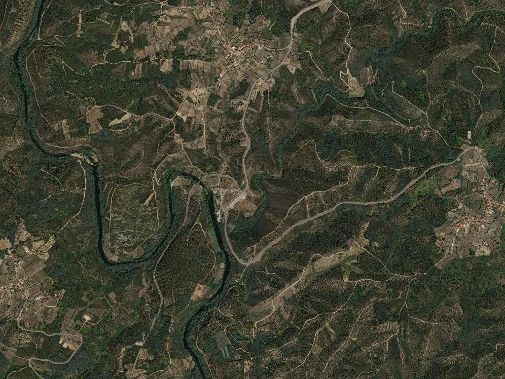
The echo of feet on granite changes pitch where two rivers draft the map. At Porto de Raiva, the Alva ends its 106-kilometre descent from the Serra da Estrela by surrendering to the Mondego. Alder and ash lean over the merger, roots fingering rust-coloured clay. Even on cloudless August afternoons the air carries a film of river breath, and light shatters across the water like scattered pewter.
Two names, one story
An administrative merger in 2013 simply rubber-stamped what geography had long decided. Friúmes—Frimianes in tenth-century charters—and Paradela, whose very name memorialises the medieval “parada”, the obligation to host passing nobility, have always shared the same fold of valley. Friúmes belonged to Poiares until the municipal shake-up of 1855 shifted the border a few kilometres east; no one here bothered to update the mental map.
Stone, carving, candle-flame
The parish church of S. Mateus in Friúmes rose again in 1779 after French troops torched the earlier building. Its facade is plain, the tower tacked on, but inside gilded carving catches the candle-light like low-burning gold. Three kilometres away, the hillside chapel of Senhora do Cabo keeps a fifteenth-century wooden Virgin, her face darkened by centuries of beeswax and palm-ash smoke. Paradela’s churchyard holds a 1730s Baroque crucifix ordered by Abbot Melchior Machado; lichen has softened the inscription but not the stone gesture of blessing that still faces the weather.
Between ridge and river
Pull off at the miradouros of Carregal, Vale do Conde or Zagalho and the same layered landscape tilts away: slate roofs below, chestnut and pine above, the rivers threading the plain like loose filament. In July the river-beach at Lapa fills with families who bring steaks and Vinho Verde—grills are communal, the water too cold for sandwiches. The old Beira road (EN17) and the IP3 slip through without haste; lorries pass, but the valley refuses to vibrate. Higher up, twenty-two windmills litter the slopes of the Serra da Atalhada—stone circles with rotting timber ribs, the jawbone of an age that ground its own bread.
Underground seams
Locals still point to the “Toca da Moura”, a mined-out seam half-smothered by brambles. No one agrees whether Romans or nineteenth-century speculators chased the narrow vein first; either way, the galleries yielded only quartz glitter. The mouth is barred now, but children are warned away with the same stories their grandparents heard—of gold that shone only in the dark.
The Torres Way
Pilgrims on the lesser-known Caminho de Torres en route to Santiago cross the parish in a single morning, counting 813 inhabitants and thirty-seven souls per square kilometre—enough silence to let a church bell travel. Cafés don’t open at dawn; pack water and a wedge of Queijo da Serra. Ask for the best sunset spot and you’ll be walked to a field edge that appears on no cartography, where the Mondego turns pewter-rose and granite glows like ember. Water, you realise, never divided these villages; it sutured them.