Full article about Sagres: Where Europe Crumbles into Atlantic Blue
Stand on the Rosa dos Ventos, feel 15th-century pilots’ bearings beneath your boots.
Hide article Read full article
The wind arrives in short, staccato bursts, flinging salt and the sharp iodine of drying seaweed against your jacket. Straight ahead the Atlantic dissolves into a cobalt seam that could be the edge of a map. Sagres sits on that edge – a scatter of white houses and low pines bolted to ochre cliffs that drop forty metres to the foam. Continental Europe finishes here; after the lighthouse at Cabo de São Vicente the next parish is New York.
A headland where latitude turned into longitude
Henry the Navigator’s fortress squats on the bluff like a slab of weather-beaten toast. Inside the reconstructed walls the only ornaments are a tiny chapel, a single fig tree bent horizontal by the wind, and the Rosa dos Ventos – a 43-metre stone compass rose scored directly into the bedrock. No one can prove Henry ordered it carved, yet the geometry is too deliberate for accident: sixteen radiating lines that once schooled pilots who would sail past the equator for the first time. Stand over it at dusk and you can still feel the magnetism: gannets arrow past on the same north-west bearing they followed in 1460.
Three kilometres inland, the Hermitage of Nossa Senhora de Guadalupe hides among gum-cistus and kneehigh heather. The single-nave chapel, listed since 1924, was where fifteenth-century crews heard Mass before risking the unknown. Sagres’ very name comes from the Latin sagrum – consecrated ground – and the place still behaves like it owes a debt to something larger than commerce.
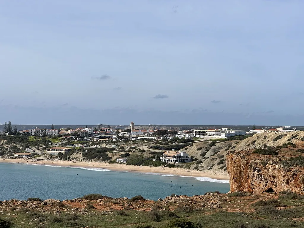
Where the Atlantic writes the timetable
The entire coast falls within the Southwest Alentejo and Vicentine Natural Park, meaning no concrete balconies, no beach bars blasting Euro-pop. Instead erosion has cut a series of amphitheatres lined with schist and limestone. Tonel Beach faces due west: when a long-period swell arrives the wave face can exceed three metres, and you’ll hear Dutch and Basque accents arguing politely over peak rights at dawn. Beliche Beach is reached by a cliff staircase so steep the council installed a handrail – descending is easy; the return is a reminder that hamstrings exist. Mareta, tucked inside a southern cove, gives the village its daily swim: a crescent of firm sand where local children practise pop-ups on bodyboards while parents read the paper weighted down with stones.
Between late August and October the headland becomes a migratory runway. Short-toed eagles, white storks, even Egyptian vultures ride the thermals that rise from the warmed cliffs. Bring a pair of 8×32 binoculars and you can log 30 species before lunch; the local birding association posts daily counts on a blackboard outside the fishing co-op.
Salt on the tongue, fire in the throat
Fish arrives in 4 °C crates straight from the auction in nearby Vila do Bispo. Order the caldeirada and a clay pot appears – monkfish, grouper and spider crab simmered with tomato, coração de boi peppers and enough coriander to make the air taste green. Cataplana follows the rhythm of its copper shell: clams, razor-shells and prawns steamed open with Alvarinho until the broth turns coral. Octopus is roasted the old way, braised first in bay and garlic, then blasted in the oven until the edges bronze and curl. Finish with a thimble of medronho – a clear, Protected-Geographic-Indication spirit distilled from the strawberry tree berry that grows wild on the Monchique hills. The first sip tastes of rose-hip and Christmas; the second convinces you you’re fluent in Portuguese.
Walking to the last light
The fishermans’ trail to Cabo de São Vicente is six kilometres of compacted earth that smells of thyme crushed under boot. The path stays within a body-length of the void: 50 metres below, Atlantic swells detonate against black schist. Halfway, you pass a stone marker dated 1497 – Vasco da Gama’s crew reportedly hauled a lateen sail this way to dedicate before their India voyage. Then the lighthouse appears, a 24-metre white stripe on basalt, first lit in 1846 and still using a 1,000-watt halogen bulb that can be seen 28 nautical miles away. Sunset is communal theatre: Germans share ponchos with Parisians, a yoga teacher from Brighton holds crow pose, someone opens a tin of sardines. The sun drops like a molten £2 coin into the ocean; applause ripples across the cliff top.
Night in Sagres is a low-frequency hum – waves, the diesel generator that powers the village, the occasional clink of a Sagres beer bottle. Your hair will still carry the Atlantic tomorrow; your jacket will still smell of woodsmoke and dill from the restaurant grill. And you will remember that you stood where the known world once ended, and that the wind is still auditioning new explorers.