Full article about Monte, Funchal: Cloud-Crowned Basalt Village
Ride wicker sleds down mossy lanes to 18th-century laurel-shaded terraces
Hide article Read full article
Monte: Where the Island Breathes Above the Clouds
The damp arrives first—before the view, before the altitude, before you’ve even stepped off the wicker-sided toboggan that has just careered 2 km down the cobbled lane from Nossa Senhora do Monte. At 847 m the air is a different substance: cooler, yes, but also greener, as though the Atlantic cloud that keeps folding and unfolding over the ridge has been steeped in laurel and wet basalt. One lungful and you realise Funchal’s sunscreen-and-espresso perfume is 600 vertical metres below.
Monte occupies 1,858 hectares of near-continuous uphill. The parish’s 5,794 residents (2021 census) live on slopes so unforgiving that level ground feels like a clerical error. Density—311 people per km²—sounds civilised until you notice the laurel forest swallowing whole hillsides where no one walks for hours. Elderly neighbours still claim the morning sun-patch in front of the church at 10:30 sharp; 27 % of them are over 65, outnumbering the under-14s by roughly three to one. The mountain is ageing, but on its own terms—slowly, quietly, like the moss re-stitching every basalt wall.
Stone That Holds the Sky
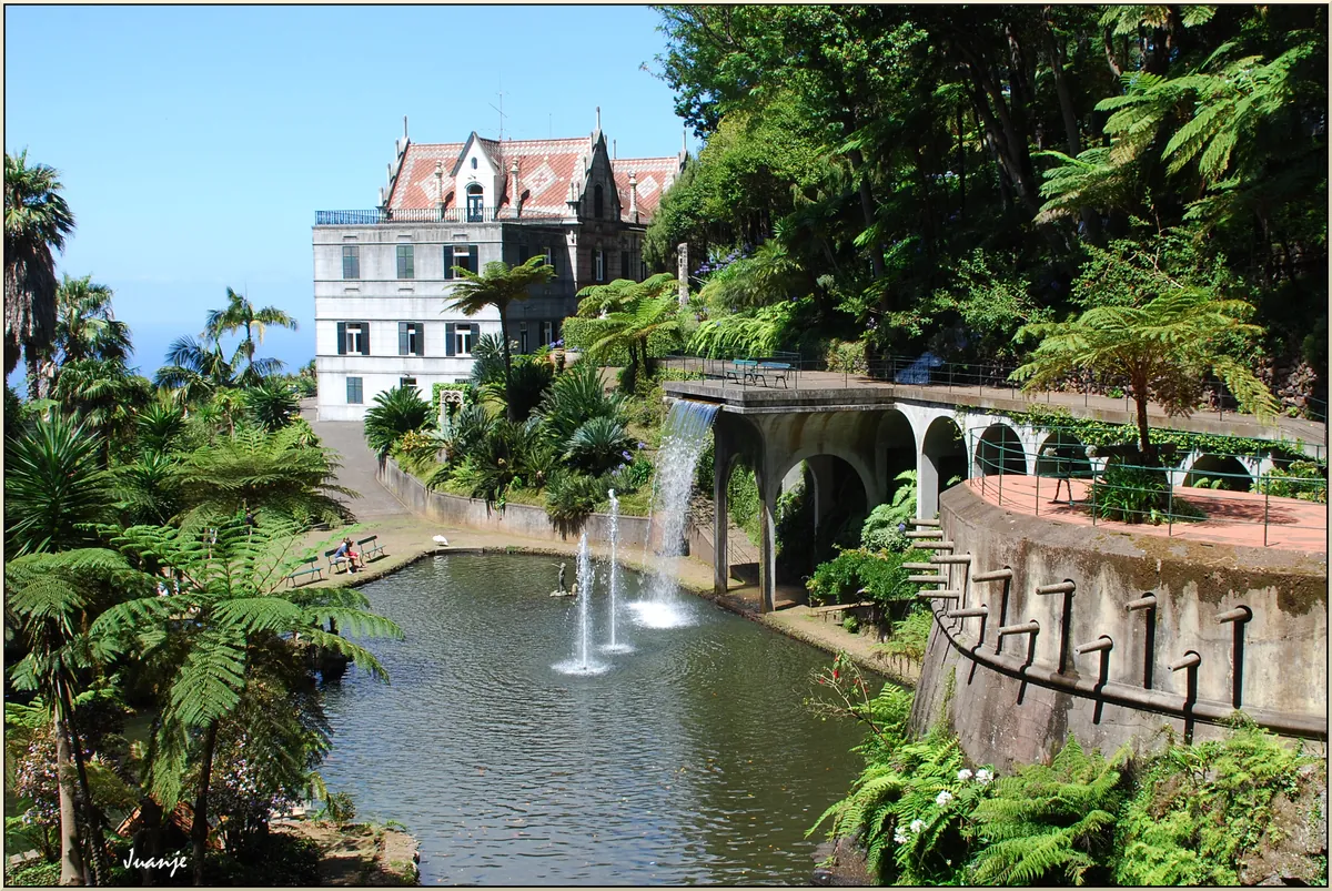
Only two buildings carry Portugal’s formal “Public Interest” seal, yet they anchor the parish like pitons. The Igreja de Nossa Senhora do Monte, rebuilt in 1741 over a 15th-century hermitage, rises in charcoal-dark basalt that drinks rain and then shines, gun-metal bright, on winter mornings. Around it, the 18th- and 19th-century terrace walls—hand-stacked by farmers who grew vines and potatoes on 40 % gradients—look less like masonry than geology that has remembered it was once useful.
Above 600 m the climate slips into a different wardrobe. Sub-tropical gives way to sub-lunar: heather, moss, the occasional stunted oak. The city’s white noise fades, replaced by water you can hear but rarely see—droplets threading through tree-roots, seeping over lichened boulders, dripping from fronds of Dicksonia antarctica that have no English name anyone uses twice.
Laurissilva: Europe’s Lost Weather System
Madeira’s laurel forest, Unesco-listed since 1999, presses against Monte’s northern edge like a green high-pressure front. Forty million years ago this ecosystem cloaked southern Europe; today it survives only here and on the Canary Islands, kept moist by Atlantic cloud and altitude. Step inside and the ceiling lifts to 30 m of twisted Ocotea foetens and Apollonias barbujana, their trunks sheened with water that never quite becomes a stream. The forest floor is a 10-cm mattress of slowly turning leaves; the air tastes faintly of iron and chlorophyll, as if someone has struck flint against spinach.
The shortest legal doorway is the Caminho do Pináculo, which starts by the toboggan terminus at Largo das Babosas (590 m) and climbs—sometimes at 30 %—to the radar domes of Pico do Areeiro at 1,021 m. Allow three and a half hours, longer if the cloud closes in and the basalt steps turn to black soap. Weather can swap sunshine for zero visibility in the time it takes to tighten a bootlace.
The Wine That Grew on Walls
Monte still sits inside the demarcated Madeira-wine zone, yet the terraces that once produced it are now archaeological. From the 1850s onwards phylloxera, emigration and a 45-degree gradient finished what good intentions began; the last commercial grapes were dug out in the 1950s. Walk the 400 m contour between the Babosas trailhead and the abandoned Monte Carlo hotel and you can trace the skeletons—low stone collars called currais, each no wider than a double bed, filled today with hydrangeas and wild nasturtium. The liquid geography in your glass now comes from gentler slopes further west, yet the island’s vertical bitterness lingers in every sip: high acidity, long echo, a finish that refuses to leave the party before dawn.
Life at 847 Metres
Daily rhythm is set by temperature rather than time. January mornings average 9.3 °C; kettles boil, shutters stay shut, coffee is strong enough to walk on. By 11 a.m. the cloud may lift, sun warming the basalt walls until they exhale threads of steam. Night brings the fog back like a rolled-out duvet, muffling the narrow lanes where fewer than 1,200 visitors stray each day—most herded straight from cable-car to botanical garden, missing the recoil of a blackbird’s song off a 19th-century culvert.
Abandonment adds its own soundtrack: the Monte Carlo hotel, closed since 1984, groans quietly in Atlantic gales; a wrought-iron gate rasping against stone sounds almost like breathing. Somewhere between 600 m and 700 m on the Caminho das Babosas, cultivated camellias give up and the forest takes over—no signpost, just a soft collapse of order into entropy. Monte exists in that seam: neither city nor wilderness, but a weather-beaten lobby between the two.
What Stays
The picture that survives the flight home is small, almost domestic: a wall built in 1873 to keep Senhor António’s vegetable patch from sliding into the valley, its basalt blocks now upholstered in luminous moss. On the tip of a lone mountain fern a droplet lingers—globe-perfect, holding the entire Atlantic sky—then falls without applause onto dark earth. No filter, no gift-shop, no hashtag. Just the island inhaling, 847 metres above the rest of the world.