Full article about Arrifes: São Miguel’s Sky-High Dairy Pastures
Climb above Ponta Delgada into cloud-brushed paddocks that fuel a quarter of the island’s milk
Hide article Read full article
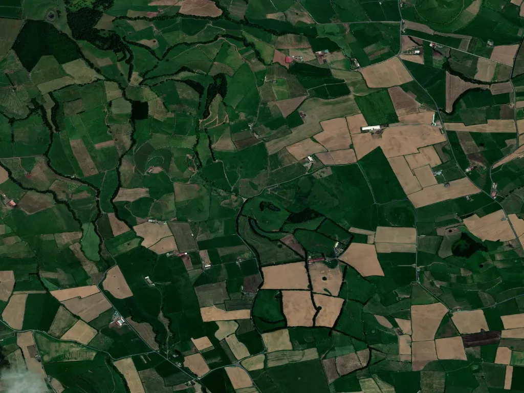
The lowing reaches you before the land does. On the climb north-west out of Ponta Delgada, before any sign announces Arrifes, the sound arrives first—an earthy bass note rolling across hedgerows and basalt walls. Cattle appear next, piebald Friesians and honey-coloured Jerseys grazing paddocks that run clear to the horizon. At 362 m above sea-level the Atlantic light thickens; low cloud drifts like loose gauze, turning the greens luminous and the blacks absolute. You have entered the island’s milk pail: 2,000 ha of pasture that supply more than a quarter of São Miguel’s dairy.
A name you feel in your calves
“Arrifes” is less a label than a warning. The word derives from the old Portuguese arrefiar— to slip or slide—and your tendons will confirm it. The parish unfurls across angled terraces, volcanic ribs pushing through turf. With 25 km² it is one of Portugal’s largest parishes, yet its population—7,294 at the last count—occupies three discrete hamlets stitched together by cow tracks and parish feasts. Expansion came late. Until 1719 this was chapel-of-ease territory, an overspill of São José; full parish rights arrived only in 1833 when the Liberal Wars ended and central government finally noticed the slope-colony that fed the capital.
Basalt, whitewash and baroque gold
Park by the hydrangeas and walk the Igreja Matriz de Nossa Senhora da Saúde. The façade is a monochrome triptych: midnight basalt carved into scrolls and urns, volcanic tufa trimmed into pilasters, lime-whitewash blinding against changeable sky. Dona Margarida Bettencourt da Câmara ordered the first stone in 1627; her 18th-century heirs added the gilded interior that now traps Atlantic light and flings it back in warm shards. Two sibling churches—Nossa Senhora dos Milagres (begun 1816) and Nossa Senhora da Piedade—complete the only devotional triangle on the island. Each owns a September romaria: Saúde on the first Sunday after the 15th, Milagres on the third, Piedage on the fourth. For four consecutive weekends the parish eats, processes and dances in the street, brass bands ricocheting off basalt door-cases.
Tanks, tractors and a cattle pageant
On 10 June the Agricultural Fair turns the central crossroads into an open-air stockyard. Judges in navy blazers palpate udders, children clutch rosettes, farmers compare somatic-cell counts the way Londoners discuss house prices. The parish’s 287 inhabitants per km² swell with cousins from Rabo de Peixe and returnees from Toronto. Meanwhile the Lira Nossa Senhora da Saúde brass band rehearses marches that sound, at this altitude, uncannily like Vaughan Williams—open chords carried across pasture until the Atlantic absorbs them.
Stone walls and green tunnels
Arrifes is best explored on foot. Follow Rua da Piedade past the font where women once laundered altar linen; water still spills over lichened basalt into a trough the colour of jade. Continue between loose-stone walls—no mortar here, just gravity and skill—until the lane narrows to a green corridor of Japanese cedar and sweet bay. The UNESCO-designated Azores Geopark begins at the gate: small volcanic plugs, collapsed calderas, and fissures where ferula and wild ginger grow two metres high. You may meet Scout Troop 433 practising map-reading; their leader will point out the 1856 gunpowder-magazine ruins, reminder of an explosion that killed four soldiers when the island garrisoned against pirates and politics.
When the fog clocks in
Late afternoon the mist arrives like a slow-exposure photograph. Cow bells grow sporadic, solemn; colour drains to charcoal and pearl. From the lane you glimpse the Matriz tower dissolved in vapour, its basalt ribs merged with the basalt earth. You smell wet pasture, diesel from a distant milk tanker, and something older—an island breathing. Stand still and the boundary between land, animal and human blurs, and you understand why Arrifes needs no postcard epithets: it has already stated, in lowing and stone, exactly what it is.