Full article about Fonte do Bastardo: the Azorean spring that named a village
Wind-buffeted paddies, black-stone walls and a trickle of water that christened a Terceira hamlet
Hide article Read full article
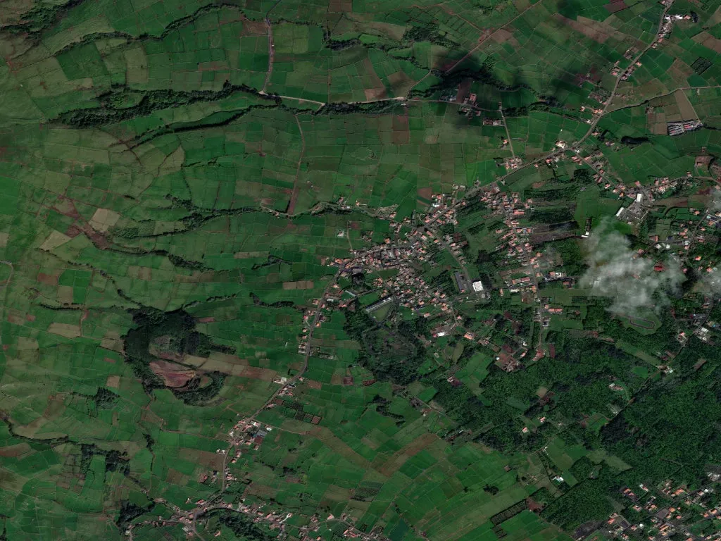
The wind arrives before the view. It slips over the brow of Serra do Cume, carrying Atlantic salt and the faint clink of cowbells, then funnels down the slope until you feel it on the back of your neck. Only afterwards do the fields reveal themselves: an origami of emerald paddies pleated by basalt walls, the stone so dark it looks wet even in drought. At 154 m above sea-level, Fonte do Bastardo clings to a crease in the ridge where springs keep the earth permanently damp. Water, not altitude, is what pinned a village to this spot five centuries ago.
How a spring got a strange name
The first settlers arrived in the early 1500s, chasing rumours of a year-round source that tasted of nothing, not even iron. They found it seeping from pillow-lava above the Ribeira dos Lagos, formed two small mirror-bright pools, then left again. Word travelled faster than people: on Easter Sunday families walked the goat track up from Praia da Vitória with wicker jugs to “fetch the source water”. The track widened, stone houses appeared, and the place acquired its eyebrow-raising name—Fonte do Bastardo—without parish records ever explaining why. Local wit claims the baptism happened after an illegitimate son of a Flemish settler built the first trough; more prosaic scholars blame a 16th-century surveyor’s in-joke. Either way, the water kept flowing, and the name stuck like moss.
When the ground shook and the sky paid
Parish church number four—the white, twin-towered Igreja de Santa Bárbara—opened on 18 December 1904, but devotion here is measured in collapses and comebacks. The original chapel slid downhill in the 1614 earthquake; for almost three centuries Mass was said in the open air or a cedar-ceilinged hermitage while priests rode in from São Brás with vestments stuffed in saddlebags. Funds for the present building came from José de Bettencourt, a local boy who had emigrated to São Paulo and cornered part of the coffee trade. His 12 contos de réis bought land, lime and craftsmen; the cedar hermitage opposite the cemetery stayed put, a quiet witness to outdoor sermons delivered in rain that could rattle rosary beads.
On 4 December the village wakes at five, not to church bells but to the thud of diesel generators powering pig-slaughtering gear. By nine the women appear in ankle-length wool coats, communion ribbons still pinned to their sleeves, carrying cornbread and the saffron-yellow sweets of Santa Bárbara that finance the altar flowers. Yet the procession that defines Fonte do Bastardo happens three weeks earlier, at four in the morning, when hundreds set out with LED lanterns swinging like fishing boats. Since 1972 mothers whose sons were conscripted to the colonial war in Angola have walked eight km to the Largo do Recanto in silent prayer. What began as fourteen women in headscarves reciting the rosary is now a river of bobbing light you can watch from the Serra ridge like a slow-motion constellation.
Lava, pasture and the sound of leaking water
Geologists come for the biscuit-black lava, the local term for ropey pahoehoe that cooled 23,000 years ago when Serra do Cume erupted and sent a viscous tongue all the way to the coast. Between 100 m and 400 m the fields are a parquet of basalt clinker stitched together with moss and hydrangeas; farmers prise blocks out with crowbars to mend walls, each lump a slice of Pleistocene midnight. Underneath, the Zé Grande lava tube zigzags for almost a kilometre—once a hiding place for contraband corn, now a bat dormitory the size of a cathedral nave.
The village spreads across 885 ha without ever quite becoming a settlement: red-roofed houses interrupt pasture every 200 m, giving a population density low enough for silence to be commonplace. At dusk you hear only the Atlantic rinsing the cliffs three kilometres away, the gurgle of the Ribeira dos Lakes slipping between mossy stones, and your own boot soles on the basalt cobbles that link fields to church, church to cemetery, cemetery to water.
Dona Albertina, 84, still draws cooking water from her cistern with a cedar bucket—“spring water is for drinking, cistern water is for soup”—and watches the sun tilt low enough to toast the volcanic stone until it radiates heat back at the sky. Out beyond her hedge the ocean flares like polished pewter. Nothing dramatic happens; that is the drama. Springs keep rising, walls keep standing, people stay. To stand here is to be folded into a continuity that began when someone first cupped a hand under a drip of clear water and decided the hill was worth the climb.