Full article about Bombarral’s cherry-scented flatlands and 1618 azulejos
Cycle orchard rows, trace Templar grids and trace 400-year-old tiles in western Leiria
Hide article Read full article
The Plain Where Cherries Ripen in the West
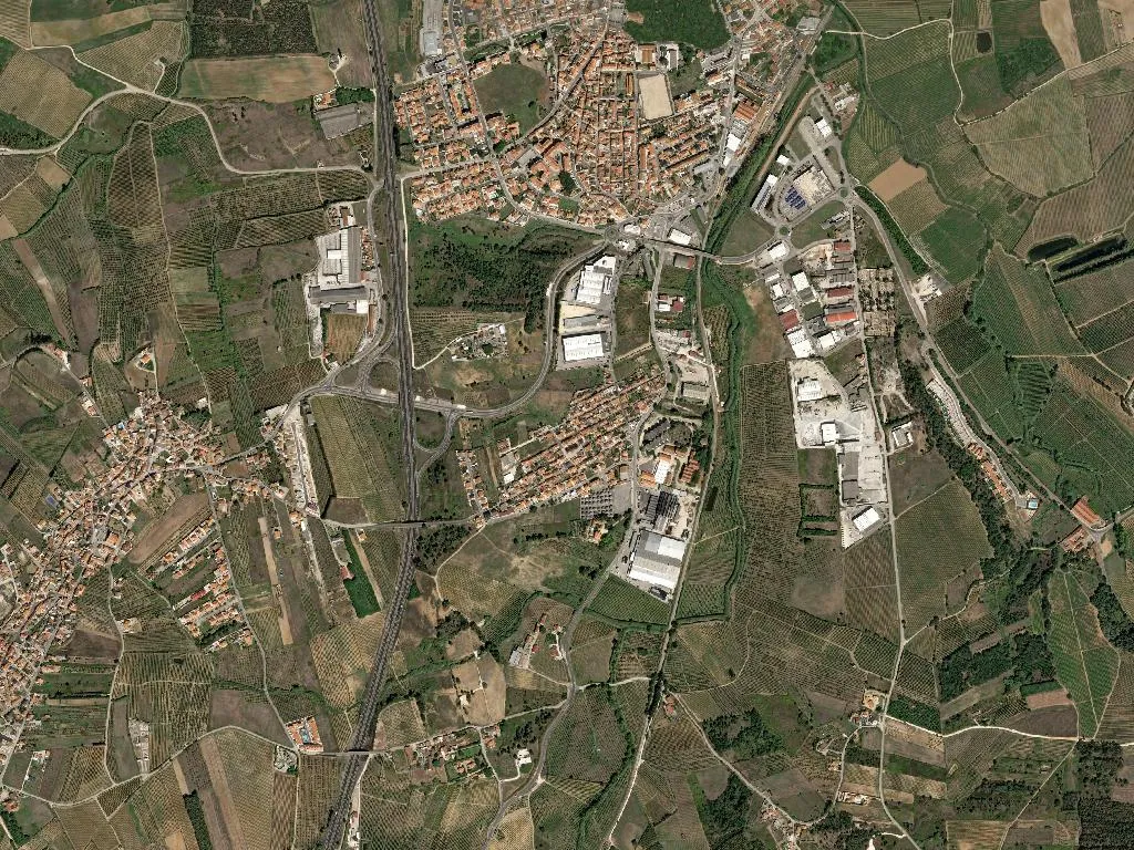
The scent reaches you before the view does. A syrupy sweetness hangs in the air above the flatlands outside Bombarral whenever summer ripens the orchards and the Atlantic—only twenty kilometres away—exhales a breeze freighted with black-cherry vapour. July, sometimes August. The trees bow under the weight of fruit the colour of a bruise, and the light of Portugal’s western littoral slices across whitewashed walls, throwing short shadows across land that barely rises above forty-five metres. Everything here is horizontal: a floodplain of alluvial soil where the eye runs unobstructed to the soft ridge that marks the edge of the municipality.
This is the civil parish of Bombarral e Vale Covo, created in 2013 when two communities merged—one clustered around the small market town, the other scattered among vineyards and orchards. Together they cover thirty square kilometres of some of the most fertile ground in the Lisbon District. Six thousand eight hundred people live here, the older ones still able to read cloud formations the way their parents read the weekly parish bulletin.
Templar grids, confraternity records and 1618 tiles
Organised settlement goes back to the ninth century, but the footprint that matters was left by the Knights Templar. No castle dominates the skyline; instead the Order’s legacy is subtler—a chess-board pattern of land parcels that still dictates how tractors turn at the end of each row. In 1575 the Confraria do Santíssimo Sacramento (Holy Sacrament Brotherhood) received royal approval, proof that the settlement had enough spiritual momentum to fund its own rituals rather than depend on a distant mother church.
Inside the parish church of Bombarral the air is cool stone and wax. Walk fifty metres up the lane to the tiny Chapel of Águas Santas and you can run a fingertip over cobalt-blue tiles dated 1618: the glaze is pitted, the edges sharp where centuries of fingers have grazed the surface. Two buildings in the parish are classified as Properties of Public Interest; both are discreet, dignified, and still in use.
Soil that gives you pears, apples and cherries
Real wealth lies below the boot. Low topography and river-borne silt create conditions that only a handful of Portuguese micro-regions can match. Three protected products originate within these boundaries: Ginja de Óbidos e Alcobaça IGP (the sour-cherry liqueur that appears in every Lisbon bar), Maçã de Alcobaça IGP, and Pêra Rocha do Oeste DOP.
Pick a Pêra Rocha in late August and the skin freckles under your thumb; bite and the flesh fractures cleanly, releasing juice with a memory of Atlantic salt. The same maritime breeze that cools August nights gives local apples their snap. As for the ginja fruit, it is small, dark and stubborn; left to macerate for months in aguardente it yields a liqueur whose flavour is the taste of Portuguese late-night conversation. Between the rows of fruit trees, low-trained vines soak up the west-coast sun and store sugar with slow precision.
Geology underfoot, ocean on the horizon
The parish sits inside the aspiring West Portugal Geopark, an area being prepared for UNESCO status. What looks like ordinary farmland is in fact a laminated autobiography of tectonic shifts and Ice-Age sediment. Walk the dirt tracks between pear orchards and you feel the give of loam that never fully dries; groundwater sits so close to the surface that even in August the soil sticks to the soles of your shoes.
You cannot see the ocean, yet it announces itself hourly: in the salt note that edges the breeze, in a sky that can switch from milky overcast to cobalt within minutes, in the silvery morning light photographers call “West Coast white”. Lisbon is forty-five minutes away on the A8 motorway, but the population density is barely two hundred people per square kilometre—space enough for a combine harvester to turn without touching a neighbour’s wall.
Walk slowly, taste slowly
Experience here is measured in small, sequential acts. Arrive at the parish church just after seven, when the nave is empty and your footsteps echo like dropped coins. Drive the lane that links Bombarral’s grid of streets to the scattered houses of Vale Covo, slowing for a tractor hauling a tank of copper-sulphate spray. Check into one of the twenty-seven local guest-houses—converted haylofts, 1950s farmhouses, a wing of a wine estate—and wake to the sound of blackbirds arguing in the cherry trees.
With 871 residents under twenty-five and 1,783 over sixty-five, the parish operates on agricultural time. The oldest residents still forecast rain by the colour of the Tagus estuary visible on the horizon; the youngest are experimenting with QR codes on apple crates. Between them the land continues to produce exactly what it always has, only now it is catalogued, certified, and shipped to Berlin or London within forty-eight hours.
Stay until the sun drops behind the orchards and the cherry trees cast shadows like long fingers across the dust. The temperature falls quickly—Atlantic air reclaiming the plain—and the taste of ginja lingers on your tongue, a dark punctuation mark at the end of the day’s sentence.