Full article about Massamá–Monte Abraão: Sintra’s Forgotten Plateau
Step off the commuter train into 3 km² where royal charters, Manueline gold and 1950s flats collide.
Hide article Read full article
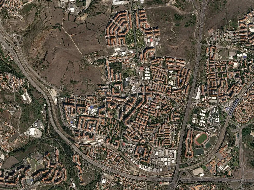
The 18.22 from Rossio brakes hard as it climbs the last incline before Sintra. Through the half-open window comes the smell of sun-warmed concrete and exhaust, a reminder that Lisbon’s commuter belt now sits 167 m above sea level. When the doors slide back at Massamá–Monte Abraão, 47 804 people are crammed into 3.28 km² of plateau—roughly the same density as inner-city Barcelona, only without the guidebook entries.
Where the place-names remember ploughs and patriarchs
“Massamá” still sounds North-African on the tongue; scholars trace it to mašmūm, “irrigated land”. The first royal charter mentioning the settlement dates from 1160, when Afonso Henriques handed the villa de Maxamâ to the canons of São Vicente. Monte Abraão, on the ridge above, acquired its biblical label in 1593 after a small chapel went up dedicated to Abraham—its gilded Manueline altarpiece survives inside the present parish church on Rua da Igreja.
The railway arrived on 2 April 1887 and turned cornfields into weekend gardens for Lisbon merchants. Administrative reformers merged the two parishes only in 2013, yet the social border remains legible: Massamá clusters around the station, Monte Abraão spills down the valley side, each repeating its own pattern of four-storey blocks, ground-floor cafés and plastic tables that scrape across the pavement every time the IC19 viaduct rumbles overhead.
Three monuments pressed between apartment blocks
In a landscape this tight, Listed buildings act like punctuation. The eighteenth-century Quinta da Piedade, with its blue-and-white tile gazebo, faces the modernist parish council offices across Largo 25 de Abril. Behind high stone walls on Rua do Rio, the Palácio do Correio-Mor—once the posting station for royal couriers—now houses the junta itself; 1957 preservation order, 2020 thermal retrofit. Around the corner, a sober nineteenth-century townhouse on Rua Dr Sousa Rosa displays a discreet plaque: painter Manuel Lapa lived here 1941-44 and produced the “Massamá Landscapes” series, canvases that look nothing like the place today.
All three sit within the buffer zone of Sintra’s UNESCO Cultural Landscape, which means even the newest high-rise must defer, in theory, to the views of the Serra that hems the horizon.
Pears, vines and what the supermarket replaced
Until the 1980s the plateau was planted end-to-end. The Pêra Rocha that now arrives in Borough Market under the West PDO was first grafted in orchards where the Alegro shopping centre and Real SC football ground stand. The last commercial vineyard disappeared in 1982 when the Cortes family sold up; two pre-phylloxera Ramisco vines still cling to the wall of the former adega at Quinta da Fonte, a living souvenir of the Colares demarcation that once stretched this far inland.
Memory lingers in street names—Rua da Eira, Travessa da Vinha, Largo do Moinho—while the weekly fruit-and-veg market in the Alegro basement imports its pears from Oeste growers who now live in Greater Paris.
Forty-eight thousand in 3.3 square kilometres
INE 2021: 6 455 children, 9 091 seniors, 31 258 of working age. That is 53 pensioners for every 100 contributors—well above the national average—yet both primary schools are oversubscribed: EB1 Massamá has 512 pupils, EB2,3 Monte Abraão 654. Geography helps explain the appeal: 18 min to Rossio on the 2023 timetable, 3.3 km to the A37 junction, eight municipal bus routes with 15-minute headways at rush hour. Among the 27 legal accommodation listings, 18 are short-let flats averaging €62 a night—cheap for Greater Lisbon, expensive for a parish whose median wage is still below the capital’s.
Concrete, acacias and the eight o’clock news
There is no postcard skyline here, only repetition: five-storey slabs in ochre travertine, balconies glazed in the 1990s, satellite dishes pointing south. Walk at ground level and the details accumulate: the three-spined acacia that somehow survives in Largo do Chafariz between the “9 de Abril” social-housing blocks; the metallic clatter of a Pingo Doce trolley on 1970s calcada that no council budget has yet replaced; the orange wash of sunset turning the Montepio building gilded for three minutes before the streetlights take over.
At 19.30, windows open simultaneously—RTP’s evening news and the hiss of sardines on the grill escape in unison. Somewhere a child rehearses lines from the 1983 soap A Banqueira, scenes of which were filmed in the EB1 playground; elsewhere a pilgrim on the Coastal Caminho follows yellow arrows along the pavement, then turns up Rua do Rio past café O Padrão, where trays of pastéis de Chaves have emerged from the oven since 1987.
Night finally settles and the plateau becomes a grid of lit rectangles: 48 000 kitchens, bedrooms and living rooms stacked one upon another, all breathing quietly at 167 m—midway between the Tagus and the fairy-tale palaces of Sintra, belonging wholly to neither.