Full article about Salt-wind mornings in Póvoa de Santa Iria & Forte da Casa
Tejo breeze, flamingo sandbanks, 15th-c fort and 1930s factory chimneys
Hide article Read full article
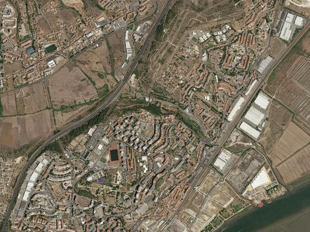
Where the Tejo drops its salt and the city exhales river
The wind rolling down the estuary carries a taste that is neither brine nor silt, but something that clings to coat collars and still smells of last Saturday’s laundry. Póvoa children learn to recognise it before they can spell their street name—an olfactory compass murmuring “home”. Morning light slaps the apartment blocks like a cautious cat-owner: slowly, so nothing takes offence. Welcome to the civil parish marriage that Lisbon bureaucracy formalised in 2013—Póvoa de Santa Iria and Forte da Casa—though the river had already joined them centuries earlier.
The fort, the factory and the flying machine
Forte da Casa calls itself exactly what it is: there is a fort, there are houses, job done. The fifteenth-century fortress once guarded the Tejo when this waterway was Portugal’s principal arterial route; whoever controlled the river controlled the kingdom. Today the stone mound faces the railway station, useful only for explaining to first-time visitors why the local roundabout carries such a grand name.
Póvoa grew beside it, eyeing the salt pans the estuary left behind. Then, in 1934, the Solvay chemical plant arrived and salt became yesterday’s headline: chlorine, caustic soda, the faint sulphur of bad eggs that grandmothers insisted “opened the bronchial tubes”. Sandwiched between these two eras, in 1912, local aviation pioneer Alberto Santos-Dumont squeezed an engine into a box of tinplate and took off from a sandbank opposite the village—Portugal’s first powered flight. Today anglers on the same bank pretend not to notice the flamingos loafing among the reeds.
Forty-thousand neighbours between floodplain and tide
The census claims 40,871 residents; in practice they are 40,871 timetable scholars. They know the 16270 is chronically late and that the 16278 exists largely for ornamental purposes. All are stacked into nine square kilometres—so dense that the couple on the third floor can tell you what the family on the fifth are having for Friday supper. Few complain: there is a supermarket open until 22h, a café where a milky coffee still costs under a euro, and a hostel for when Cascais relatives visit and refuse the sofa.
Carolino rice and orchard pears
Carolino rice is the Ronaldo of grains: born upriver, claimed by everyone. Simmer it lazily, leave it to swell for half an hour, and you will understand why locals say Póvoa rice is not eaten, it is embraced. Pair it with a sun-warm Rocha pear—the kind that snaps cleanly when you break it—and you have the perfect supper for an evening when RTP1 is screening a domestic film. Wash it down with a local white that neither fattens nor thins; its sole job is to keep the rice company.
The estuary as cathedral
Here the true place of worship is the Tagus estuary. No bells, just flamingos; no vicar, just herons. In winter the migrants descend like German tour groups—organised, loud, itinerary in claw. The land is so flat the sky sits like a saucepan lid: grey days tighten the lungs, blue ones send even the cats scrabbling up river walls for a better view. Bring binoculars, water, and a chouriço-stuffed bread roll for the end—there is no finer altar.
The first weekend in September
That is when Póvoa pulls on its football shirt: the Festa de Nossa Senhora da Piedade. Some claim it honours the patroness; others insist it merely licenses the party. What counts is that the bifanas are plate-sized, the doughnuts are hot, and the super-strength zucol malt drink stops traffic—literally. The manger sits on Largo do Coreto but the procession struts along Avenida da Liberdade—yes, the one with the Continent hypermarket and the eternally red light. For once the estuary is upstaged: the reek of charred sardine masks the salt, and even the flamingos seem to agree it is wiser to stay away.
What the tide leaves behind
When you leave, fine sand hides in your shoe seams—Póvoa’s way of saying “come back when you like”. And you will—if not for the salt-stained cobbles then for the 16270 that, against all odds, still gets you there eventually.