Full article about Laranjeiro–Feijó: Oranges Thrive Between Tower Blocks
Laranjeiro–Feijó still scents its concrete with fig sap, bitter oranges and grilled sardines, hiding a 16C chapel and 18C manor amid 1960s Almada flats.
Hide article Read full article
Laranjeiro–Feijó: concrete balconies, fig-scented air
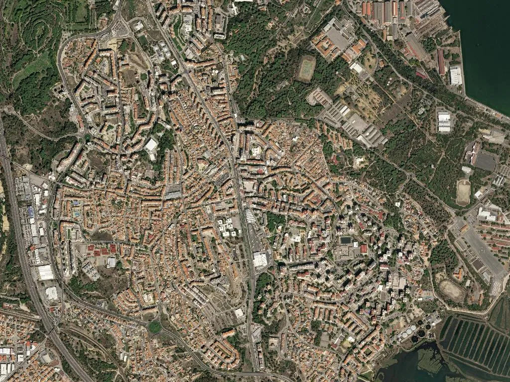
The Metro-Sul bus exhales at the roundabout and the doors sigh open. In the same breath you catch diesel from the N10 and something greener—wet soil and fig sap drifting over a breeze-block wall. That first inhale tells you exactly where you are: a parish of almost 40 000 people squeezed into eight square kilometres on the south bank of the Tagus, where five-storey slabs went up so fast in the 1960s that the orange trees never received the eviction notice. They simply keep fruiting behind car-parks and school yards, bitter Seville oranges thudding onto asphalt louder than any planning regulation.
The orchards that refused to leave
Laranjeiro—“orange-tree”—was still a slope of smallholdings when the Almada town hall approved 1 600 social-housing flats in 1964. The blocks were thrown up for lisboeta factory workers who crossed the river on rust-red cacilheiros; each flat came with a two-square-metre balcony just big enough for a tin of petunias and a clothes prop. Feijó, a hamlet further inland, held out longer: until 1980 its lanes were narrow enough to touch both walls with out-stretched arms and the ground was still compacted earth. Administrative fusion in 2013 stitched the two places together, yet walk from the metro terminus in Laranjeiro to the parish church in Feijó and the atmosphere loosens—buildings drop a floor, cafés switch from espresso to bica slowly, and the evening smells of grilled sardines rather than exhaust.
Stone bookmarks in a paper-back suburb
Two official monuments keep the timeline honest. The Manueline portal of the sixteenth-century Capela de Nossa Senhora da Saúde in Feijó was scrubbed clean in 1998; up close you can still see the salt wind has already begun re-etching the stone. The Palácio do Relógio, an eighteenth-century manor now housing the parish council, served as the manual telephone exchange until 1978—plug-and-cord operators who knew every neighbour’s business. Both buildings stand at right angles to the 1975 grid of streets named after revolutionary dates—1 May, 25 April—like calendar pages jammed into architectural concrete.
Cliffs you can almost smell
Three kilometres south-west as the gull flies, the Fossil Cliff Protected Landscape drops 40 m to the Atlantic. On winter mornings, when a northerly scours the sky colourless, the escarpment feels close enough to taste. The parish itself sits 52 m above the Tagus on a Miocene shelf; turn off Rua dos Lusíadas at the right angle and you’ll notice the pavement tilting imperceptibly toward the fossil-rich sandstone that underpins the entire south bank.
Yellow arrows among the shopping trolleys
The Central Portuguese Route of the Camino de Santiago cuts straight through the parish, entering beside the health centre and exiting past discount supermarkets. Thirty-five registered beds—ranging from D. Rosa’s two-bedroom flat (she started in 2015, leaves custard tarts on the table) to a garden plot where cyclists can pitch a tent—mean pilgrims share dawn pavements with pensioners queuing for bread. Waymarks are sprayed on lamp-posts at the height of a walking pole; locals use them as informal bus stops.
Demography that reverses at bell-time
Census figures read like a cautionary pyramid: 8 819 residents over 65, only 5 478 under 14. Yet the equation flips at 16:00 when four primary schools disgorge rucksacks, footballs and scooters. The Laranjeiro day-centre still runs Tuesday bingo for 120 women who remember the first orange groves being uprooted, while the 1º de Maio football club—founded the same year as the revolution—trains under floodlights on a pitch where vegetables grew until 1975. Ageing is relative here: the parish is older than its children but younger than its memories.
Vineyard credentials in a tower-block postcode
Few associate tower blocks with Setúbal’s muscatel, yet the denomination begins just south of the parish boundary. Bottles of Moscatel de Setúbal from Azeitão appear in Feijó grocers at €6 a litre; Café O Manel pours 60-cent glasses on Friday nights while regulars slam Sueca cards onto Formica. The wine’s apricot scent drifts out onto streets named after agricultural cooperatives that no longer exist, proof that geography outlives politics.
The soundtrack after rush hour
Traffic on the N10 never truly stops, but around 22:30 it thins enough for another noise to surface: the metallic tick of a hose watering vegetable plots behind Rua do Ferragial. Someone is irrigating kale and tomato vines in the only strip of ground the developers forgot—an audible relic among 40 000 lives stacking plates, lowering blinds, finishing homework. Nothing spectacular, everything real.