Full article about Vila Seca & Santo Adrião: Schist, Chestnuts & Baroque Proces
Terraced vines, PDO chestnut groves and 18th-century chapels cling to Armamar’s sun-scorched slopes
Hide article Read full article
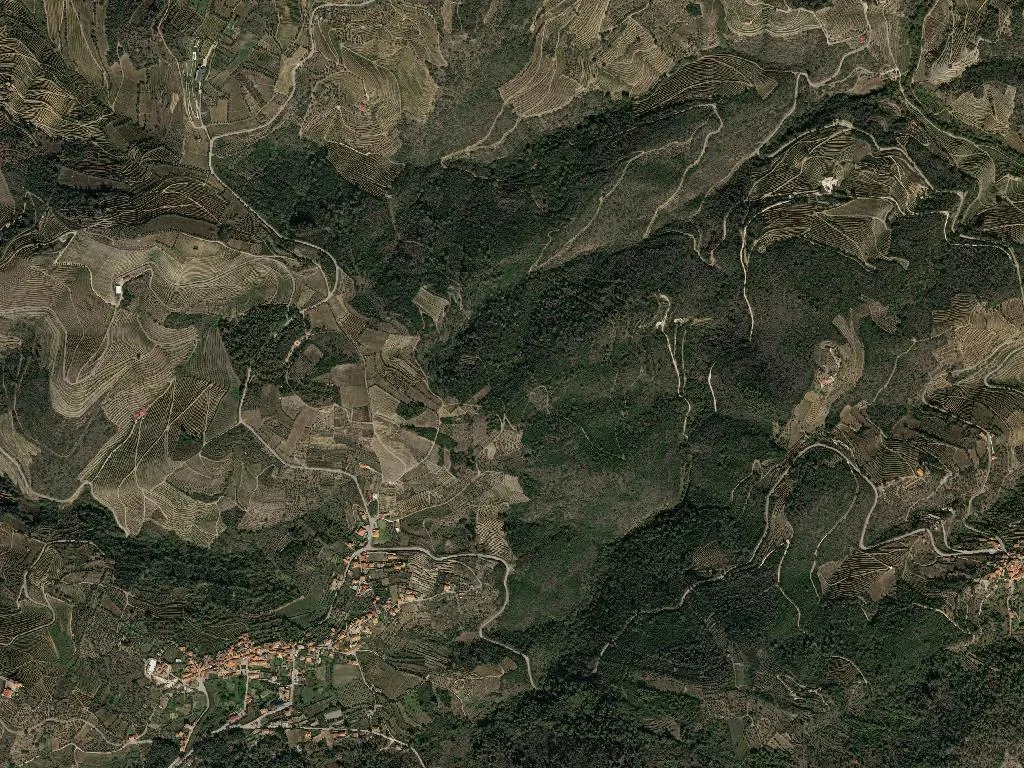
Dark schist breaks through the hillsides like bone through skin, parcelled into razor-straight terraces that pin the vines to slopes falling away towards the Douro. Late-afternoon sun heats the stone until it singes fingertips, while the valley air carries the raw scent of newly-turned earth laced with the jammy perfume of Touriga Nacional ready for picking. Vila Seca and Santo Adrião were formally welded into a single parish in 2013, yet the landscape had already done the job centuries earlier.
Where stone keeps the faith
Two Baroque churches anchor the hamlets: Santo Adrião’s parish church, its façade striped with schist and white paint, and Vila Seca’s Misericórdia chapel tucked beside the town’s pillory. Together with the chapels of São Sebastião and São Roque, plus Vila Seca’s 17th-century granite cross, they form the municipality’s five listed monuments. Walls a metre thick keep the interiors cool enough for candle wax to resist melting even in August. The calendar still pivots around processions: Nossa Senhora da Piedade on the first Sunday of September, Our Lady of Sorrows on 15 August, and the Feira de Santiago on 25 July—an open-air market that has filled the same square since at least 1758.
Chestnuts with a protected postcode
Between the vineyards lie 80 hectares of chestnut grove, the Soutos da Lapa, awarded PDO status in 1996. The trees—concentrated around Lapa, Póvoa and Valverde—yield roughly 250 tonnes a year. Come October, farmers light roadside bonfires, roast the first nuts and pour jeropiga, the fortified grape must, while singers trade improvised desafio verses that echo off the terraces.
Vineyards that run to the horizon
These rows are part of the Alto Douro Wine Region, a UNESCO site since 2001. Most of the walled terraces were hacked out between 1756—when the Marquis of Pombal demarcated the world’s oldest regulated wine region—and 1850, when British merchants were still shipping Port downriver in flat-bottomed rabelos. Altitude swings from 350 m to 650 m, giving the reds a cooler spine than the baking lower Douro. Pickers arrive from Viseu and the Beira Interior every mid-September; by mid-October the granite lagares are purple with juice.
A landscape you can drink
The census tells its own story: 628 residents in 2001, 410 in 2021. Of the 37 quinta estates counted in 1980, only 18 still produce wine. Quinta da Lapa, documented since 1733, bottles 80,000 a year; Quinta do Sagrado opens its 25-hectare property to visitors each Wednesday and Saturday (book ahead). At dusk the oblique light sets the schist terraces glowing as if varnished; the smell of fermenting must drifts from cellar doors, and at seven o’clock—as every evening—the bell of Santo Adrião tolls across the valley, a sound that has outlived both emperors and empires.